 Airport
 Island
 Region
 Village
Lonely Planet Croatia Edizione Inglese

22,00 €
Buy on Amazon
 Attraction
 Citta
Citta Nazione
 Landscape
 Beach
BeachIf you are planning your trip to Croatia, on the interactive map on this page you can find all the places of interest, islands that we recommend you visit and other useful points for your trip. You can then view cities of art, attractions, beaches, coastal villages and other tourist locations, as well as places of interest such as airports, covered on our site: simply click on the placeholders on the map, or in the list just below, to go to the in-depth tabs on the individual point of interest.
However, if you are used to organising your itineraries with a traditional paper guide, we recommend that you purchase one of the following directly from Amazon.


If you are about to discover Croatia by car and want to have a detailed map at hand at all times, or if you simply want to really switch off and disconnect from technology, there is nothing better than the good old road maps. On Amazon you will find all the most important road maps of Croatia at often discounted prices.


Below is a map of Croatia to download and print out. Click on the image for the high-resolution version.
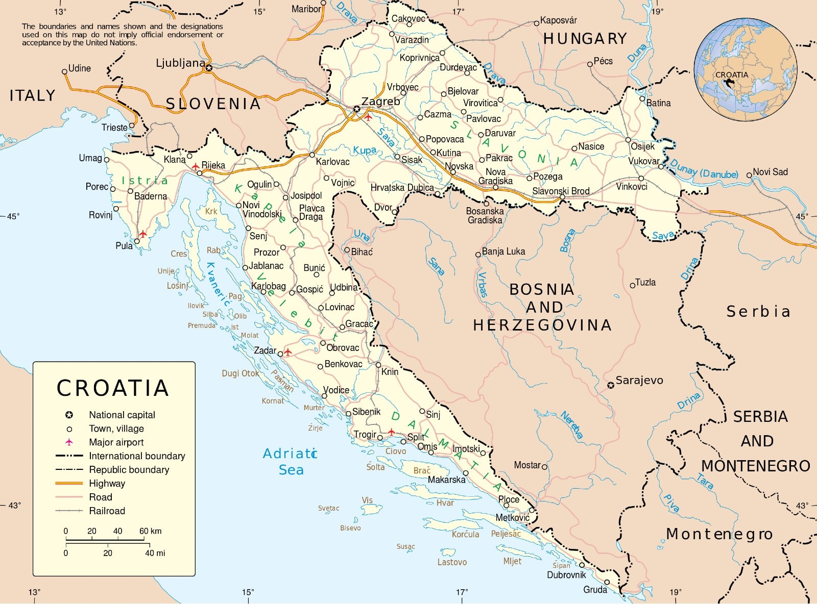
Croatia is a country located in southern Europe and stretches across the northwestern part of the Balkan Peninsula. Croatian territory is traversed by the Dinaric Alps and the country is bordered to the north by Slovenia, to the northeast by Hungary, to the east by Serbia, to the south by Bosnia and Herzegovina and Montenegro, and to the west by the Adriatic Sea.
Croatia gained its independence in 1991 after the dissolution of Yugoslavia. Since 1 July 2013, it has been part of the European Union and its capital is Zagreb. Its territory is characterised by areas with different morphological, climatic and geographical features. In particular, in the easternmost part of the country is a vast flat area, in the centre are the main mountain ranges (the highest peak is Mount Dinara at 1831 metres), while further west is a long coastal strip.
With almost 6,000 km of coastline, 1,000 islands, beautiful National Parks and a truly unique historical heritage, Croatia is a popular tourist destination, especially during the summer season.
From an administrative point of view, Croatia has 20 regions (županijea in Croatian), plus the city of Zagreb, which, as the capital, constitutes its own entity. In addition to the regions, the country also has 127 cities (grad) and 424 municipalities (općina).
 Hotel
Hotel  Budget accommodations
  Apartments
  Family Hotel
  Luxury Hotel
  Resorts